

What is a FEMA Flood Map? Flood Map Explained
A FEMA Flood Map (officially called a Flood Insurance Rate Map or FIRM) is a tool created by the Federal Emergency Management Agency. It shows flood hazards in a community and identifies areas that have a higher or lower risk of flooding.
These maps are used by:
-
Homeowners and buyers – to understand flood risk for a property.
-
Lenders and insurers – to decide if flood insurance is required.
-
Communities – to plan development and enforce building standards.
How to Read a FEMA Flood Map
Flood maps are layered with symbols, zones, and lines that show flood risk. Key parts include:
-
Flood Zones
-
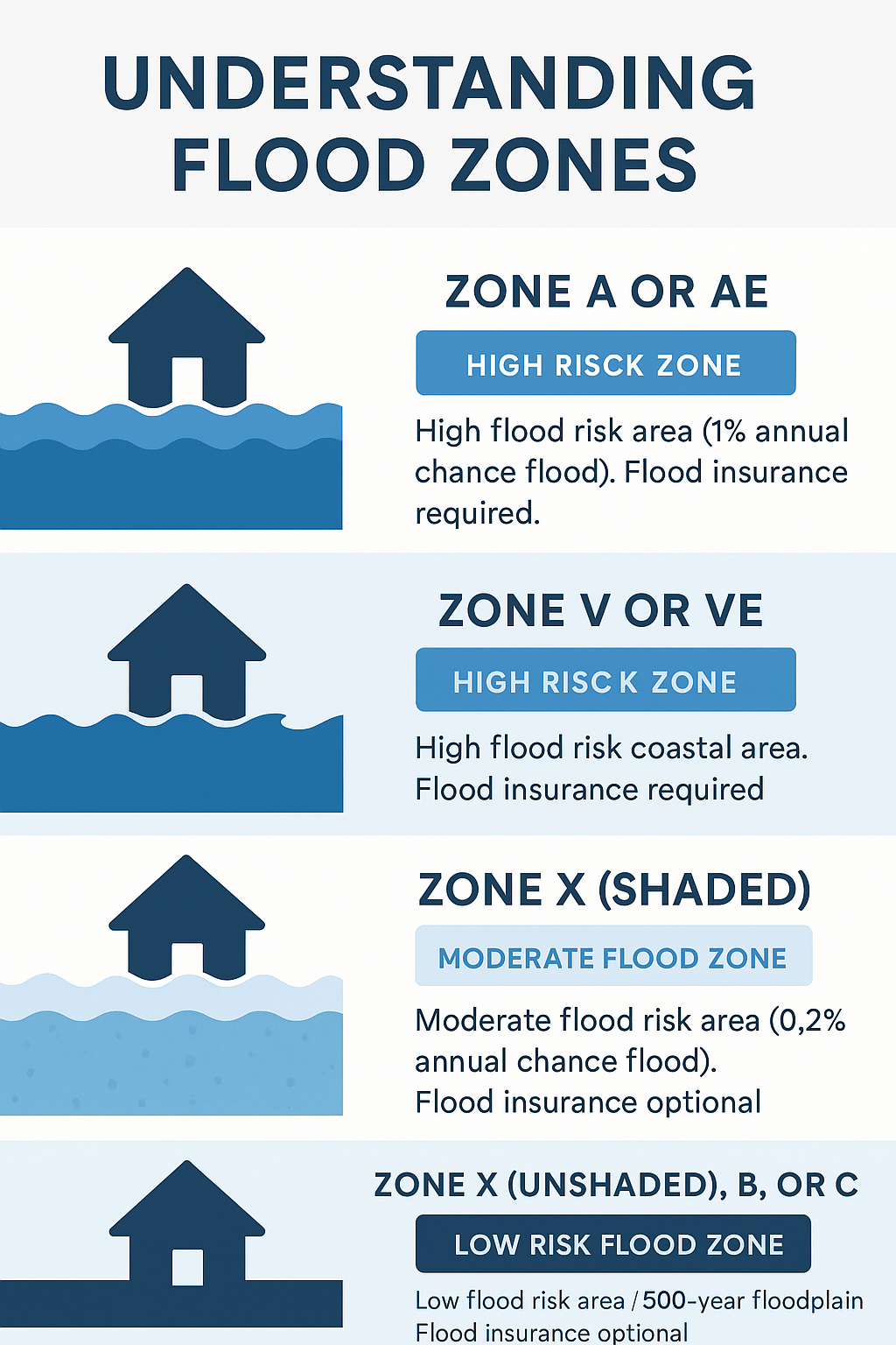
High-Risk Areas (Special Flood Hazard Areas – SFHAs):
-
Zones A, AE, AO, AH, AR, A99, V, VE
-
These are the areas most likely to flood (1% annual chance, also called the “100-year floodplain”).
-
If your property is in one of these zones and you have a federally-backed mortgage, flood insurance is usually required.
-
-
Moderate- to Low-Risk Areas:
-
Zones X (shaded or unshaded), B, C
-
These areas still can flood, but the risk is much lower. Flood insurance is optional but often recommended.
-
-
-
Base Flood Elevation (BFE)
-
The height water is expected to reach in a 1% annual chance flood.
-
Properties below the BFE are at greater risk.
-
-
Floodways and Special Features
-
Floodway: The channel of a river/stream and adjacent land that must be kept clear to carry floodwater.
-
Coastal Zones (V, VE): Include risks from storm surge and waves.
-
Why FEMA Flood Maps Matter
-
Insurance: Determines if flood insurance is required and how much it costs.
-
Building Requirements: Homes in high-risk zones must meet elevation and construction standards.
-
Real Estate Decisions: Buyers and sellers can use them to evaluate risk and property value.
How to Find Your Flood Zone
You can search any U.S. address and check the status of your property on FEMA’s Flood Map Service Center:
👉 https://msc.fema.gov/portal/home
✅ In short: FEMA flood maps show your property’s flood risk. If you’re in a high-risk flood zone (A or V), flood insurance is usually required. If you’re in a moderate or low-risk zone (X, B, C), insurance is optional but still wise since floods can happen anywhere.
Learn more at HERE
Categories
Recent Posts


"Words cannot express our gratitude and thankfulness that Keith provided us when buying our home. Being a military family and not being able to physically be there is beyond challenging buying a house unseen. He made this whole process so pleasant and easy, always easing our minds because he had our complete best interests in his hands. He took the time to send videos, pictures, and did several walk-through of the home to make us feel like we were there. You can easily tell Keith has years of experience , always answering questions and helping us every step of the way! He was extremely helpful in guiding us through the process of buying our home, and making sure that everything was taken care of promptly and correctly. He has been nothing but extremely responsive and excellent since the first phone call! Keith is incredibly knowledgeable, a go-getter, and super professional. We truly sat in passenger seat and let Keith do the driving. He went above and beyond to find the perfect home for us. There's not another realtor out there that could've provided us with the ease and comfort knowing we were making all the right decisions! Keith and Sheila have our highest recommendation, and we wouldn’t ever want to work with any other agent. We will refer our friends and family to Keith and Sheila Realty again and again!" Nicole Olson - 2024